
X-Info Maps is a web mapping tool that allows you to share your spatial information anywhere. Most data now includes some form of geographic content. The ability to share this data through one simple to use interface, empowers staff to make informed and accurate decisions, saving time and money.
X-Info Maps allows any authorised user to access your spatial data, taking the pressure off GIS specialists. Geographic data, associated attribute information and any field data that has been captured can be viewed, queried or printed.
 Investing in X-Info Maps can provide you with a cost effective decision making system. It’s priced as an entry level web mapping application, providing value to a company of any size. Put your company in the picture today by improving communication, saving time and reducing costs with X-Info Maps.
X-Info Maps is a registered and certified Australian Made product.
X-Info Maps at a glance

More about X-Info Maps
X-Info Maps centralises the management and organisation of your spatial information. It provides custom access to your data for anyone in your organisation as well as for approved external users. X-Info Maps displays data through an easy to use interface, supporting file formats such as MapInfo TAB, Esri Shape, AutoCAD, JPEG and ECW. Users have access to functionality such as layer styling and display, attribute searching, hot linked data, measuring tools, map layout and printing.
Users can mark up maps and share them with others prior to printing them on company templates. Enhanced security allows you to control which layers are visible to specific users, ensuring data integrity is not compromised. X-Info Maps administration is fully web-based, allowing convenient data editing, uploading and user management.

Share your information
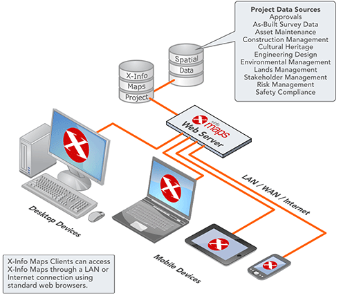
The X-Info Maps solution provides you with the ability to share your spatial data with any user through a standard web browser and interface. The data can be viewed, searched and queried, giving users the analysis tools they need to make informed decisions.

Reduce your costs
X-Info Maps is fully web based, providing a complete mapping system that can be easily accessed and administered. An unlimited number of users and datasets are supported, letting you deliver the right information to the right people. And you can keep your costs down by hosting on Mipela’s cloud service.

Improve your turnaround times
The uncomplicated X-Info Maps interface means little or no GIS experience is required for users to search, query, create, and share their own maps and layer mark up. Customised templates simplify map production, promote information exchange, and ultimately improve the decision making process.

Centralise your information
X-Info Maps stores your information in a central location, providing all users simultaneous access to the same data. Quality spatial information can also be embedded within other X-Info Suite products, like X-Info Connect and WebConnect.
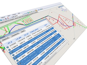
Searching and Querying
Layers stored in X-Info Maps contain searchable attribute information. Users have the ability to search and query any data associated with a layer. This includes textual information, photos, documents or diagrams. Query results are displayed in table format, highlighted in the map and can also be exported or printed.
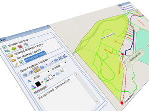
Map Mark Up
Customisation of maps is available to users through the mark up feature. A mark-up layer can include objects such as text, callouts, points, lines and regions. The layers can be saved and shared, allowing other users to view and edit the same layer in real time. Mark up layers can be exported or added to a print layout for printing on company specific templates.
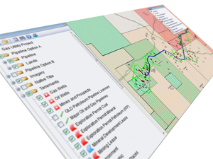
Layer Control
X-Info Maps provides users with the freedom to display layers in the map window as they require. Even basic users can apply styling, labelling and scaling to layers through the layer functionality.
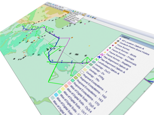
Customised Views
Provide users with quick and easy access to customised views of layers or locations. Common locations can be stored as saved locations, which users can simply select to display from the main toolbar. Stylised map layers can be saved as selectable tabs, allowing themed map views to be instantly accessed and presented in the map window.
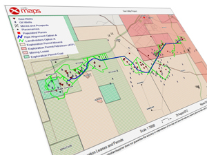
Printing and Map Output
Easily create customised maps using the printing and layout tools. The print tools simplify map layout and design and allow users to generate maps in a range of sizes and orientations. Maps can be produced as hard copies or as PDF files.
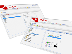
System Administration
X-Info Maps administration is web based, allowing comprehensive control over user access and permissions to map projects. Administration functions include: creating and editing projects and map layers; uploading data; and managing user permissions.
System Requirements
Operating System
Minimum Windows Server 2012
Software Required
Microsoft Internet Explorer 11.0
Email Setup
- IMAP enabled server or Exchange Server with EWS enabled
- The email server is expected to receive large volumes of traffic. It is recommended the server has no traffic restrictions or limitations.
Web Server Options
- IIS 8.0 or higher
- .Net 4.0
Supported Formats
GIS Vector Data Formats
- MapInfo TAB Format (excluding MapInfo Grid Files)
- TAB files on Access Database (.mdb)
- ESRI ArcView Shape File (SHP)
- Shapefile spatial index files (.sbn)
- Oracle Spatial Tables (8.1.7 or later)
- Personal Geodatabase
- ArcSDE connections
- GML and KML files
- SQL Server Spatial
- ESRI File Geodatabase (only supports sequential processing, not parallel processing)
- WFS – Web Feature Service
- PostGIS
GIS Raster Data Formats
- GeoTiff (TIFF)
- ERmapper Compressed Wavelet – ECW (with internal geo-referenced header information or Tab header file).
- JPEG – JPG (with world file – jgw)
- JPEG2000 – jp2
- WMS – Web Mapping Service
- ESRI Mapping Services
Databases Supported
- SQL Lite
- SQL Server
- PostGIS
System Architecture
Key applications
- Manage location-based assets, people and property
- Deploy networks, infrastructure and utilities with confidence
- Map resources, plan logistics and prepare for emergencies
Current sectors
- Energy Exploration
- Energy Generation and Distribution
- Mining and Resource Development
- Water and Wastewater
- Pipeline, Power, Telco, Road and Rail Infrastructure
- City and Regional Councils
- Engineering, Construction and Communications Consultancies


