Category Archives: Spring 2021
ARTC implements X-Info DBYD suite as their automated response system
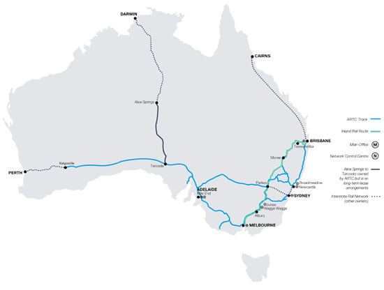
![]() ARTC is a vital part of the transport supply chain for Australia with a 8,500 km rail network across five states and working with rail operators to provide access to rail for business and producers across Australia.
ARTC is a vital part of the transport supply chain for Australia with a 8,500 km rail network across five states and working with rail operators to provide access to rail for business and producers across Australia.
Earlier this year, Australian Rail Track Corporation (ARTC) contacted Mipela to discuss automating their Dial Before You Dig (DBYD) responses.
Being a DBYD member, ARTC up until this point had been manually responding to each enquiry.
The business required a fast and reliable response system that directed all enquirers to seek authorisation before breaking ground within a radius of the rail corridor.
Ensuring timely responses provides ARTC with visibility of these enquirers’ requests in the interactive map on the X-Info DBYD suite dashboard.
ARTC now have a responsive and reliable system working 24/7 providing peace of mind.

Beware the Spreadsheet

If you’re managing your stakeholders on spreadsheets, you’re putting your project at unnecessary risk.
Spreadsheets have poor security for often important information and data quality can easily be compromised by user error or inputting of replicated data. Version control can be a nightmare and this also puts the integrity of your data at risk. This is especially the case when you have multiple people accessing the same spreadsheet. There is also a strong inability to track who makes changes or deletions – intentional or otherwise.
Designed to be more of an accounting tool than a data repository, spreadsheets don’t have great search and collate capabilities. Reporting is tedious – pulling a report from a spreadsheet is like pulling teeth!
Often stakeholder management professionals are more right brained than left – not very methodical and process driven. Basically, stakeholder management professionals aren’t suited to using spreadsheets.
The time it takes to enter and re enter information into a spreadsheet is costly and takes stakeholder management professionals away from their core role – engaging with stakeholders.
Mipela recently released a stakeholder management solution that is quick to deploy simple to use. X-Info Stakeholder Management is a commercial-off-the-shelf product that provides you the ability to capture, find and report on all stakeholder interactions. Send us your user details and existing information in templates we provide you and we’ll get you up and running in just a few days. From there you can add additional functionality to the solution as you need to by utilising our Technical Support Contract (TSC) or bundles of TSC hours for more detailed enhancements.
There’s more info available here on our website.
Contact our Client Success team for more info on +61 7 3252 5589 or info@mipela.com.au.

If you are breaking ground out in the field – we have you covered!
X-Info Plans Management is a web based app that automates the collation of your incoming DBYD responses.
With X-Info Plans Management, you simply lodge your enquiries with DBYD, then receive a single notification to let you know all responses are ready for viewing through the X-Info Plans Management app where your staff can access all maps, documents and associated communications.
X-Info Plans Management now has a new tab called Plans Management Field Portal specifically designed for field workers to view on their smart device.
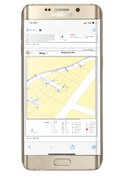
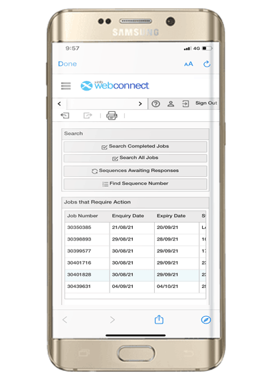 This new tab allows easy viewing for field crews to quickly search and retrieve all the responses to the DBYD enquiries that they have lodged. All information is made available in an easy to view format and there is no chance mixing up responses from another job, we have filed them all together. One enquiry gives you all the responses, letting you get on with the job.

Once open, you can share a PDF response vie email, text or any other messaging service to external parties by using the forward option at the bottom of the screen.
There’s more info available here on our website.
Contact our Client Success team for more info on +61 7 3252 5589 or info@mipela.com.au.

Popular Posts
A Word from The BossAGL Property Portal modernisation project
Kamapim update
In Focus – Do You Remember?
Meet the Products Team
Protecting Your Data and Assets in the X-Info Suite
Changes to Queensland cadastral data
Staff updates
Brissie to Bay 2026
OLDER POSTS:
A word from the Boss
Automating the encroachment process
Kamapim end of year wrap-up
In Focus – tips and tricks
Product update
Security wrap-up for 2025
BYDA Utility Safety Conference
Staff update
Christmas trading hours
A Word from The Boss
Supporting Australia’s Renewable Energy Zones
Cultural Heritage and Community Responsibility: Insights from Barada Barna
Kamapim Update
Are Your Low Cost Digital Services Scrutinised?
InFocus
Product Update
Staff Update
A Word from The Boss
Security Update: AI in the Workplace – Hype, Hope and Hidden Risks
Multinet Gas Networks & X-Info Assurance suite: Mapping Out Another GE Smallworld success!
InFocus: Your Support Experience is Getting an Upgrade
Kamapim Update: Driving Continuous Improvement Across People, Product and Industry Insight
Product Update: X-Info Connect’s New Look!
Staff Update: Introducing Leo Liu
#projectMAD Team Update: 2025 Multiple Sclerosis (MS) Brissie to the Bay Fundraising Ride
A Word from The Boss
AGIG – Enhancing Landowner and Stakeholder Engagement
The Power of Real Time Data in the Energy and Infrastructure sector
Kamapim Update: An Unforgettable start to the year with Korrin Barrett
Assurance from a Telco’s perspective
Navigating the Complexities of Renewables Projects: A Smarter Approach to Stakeholder Management
Managing Landholder Relationships to Support Social License
The Power of Clean Data
Security update
A Word from The Boss
Gas Pipeline Victoria: Streamlining Right of Way Fault reporting
In Focus
GIS: Powering the Future of Energy with Mipela
Kamapim update
Staff Update: 21 Years of Being Awesome
Renewables Protection: Beyond Fences and Private Land
Streamlining Pipeline Patrol and Sightings Management
Product Update
Security update
Christmas trading hours
A Word from The Boss
Welcoming Inner West Council
In Focus: New Support Portal
Kamapim Update: Strategic Progress and Future Innovations
Staff Updates: Introducing…
Mipela Leads the Way in Sovereignty and Security
Christmas is coming…
Development Update: X-Info Connect version 8.0
Unlocking Innovation with AWS Serverless: A Proof of Concept
Epic Energy Powers Forward: Contributing to South Australia’s 2030 Renewable Energy Goals
Staying Ahead of Key Security Concerns for Asset Owners
A word from the Boss
Taking mobile data capture to another level
The importance of Multi-Factor Authentication
Product Update – X-Info Aware
Effective land management across the Gas Pipeline Victoria
It’s the stuff you don’t see that’s keeping you safe
Ampol joins our Client Community!
Ensuring Smoother User Management: Your Collaboration can Expedite the Process
SA Power Networks – Committed to Ensuring Security
Providing you that extra level of assurance
Do you have reporting fatigue?
Focus on the complex, the urgent and the sensitive
Making light work of Safety Management Studies
Safeguarding access and data integrity – the significance of using personal credentials to log onto software
Reporting Stakeholder Information to the Regulators
What integration with SPEAR means to Jemena
A truly epic project
The true power of data automation for Jemena
Tweed Shire Council using technology to deliver value to ratepayers
Using software to safely plant trees
How mapping retirement homes helps LendLease manage its 14,000 dwellings
Stakeholder management and a global wind energy company
ERA Water automates its asset protection with X-Info DBYD suite
ARTC implements X-Info DBYD suite as their automated response system
Beware the Spreadsheet
If you are breaking ground out in the field – we have you covered!
When community focus is key to the success of your project
How Gladstone Area Water Board saves time processing permits using X-Info DBYD suite
Mipela delivers more efficiencies to APA Group
Managing Cultural Heritage across Barada Barna land
Ever wondered how TransLink manage their Bus Stops?
Managing contaminated land compliance
Systematising pipeline risk management
Experience really counts when it comes to stakeholder management
City of Greater Dandenong implements DBYD automated response system
Stakeholder management – the answer is blowing in the wind
Flavour of the month – renewable energy projects
Automation in Remote Regions Delivers Multiple Benefits to Council
Powering through South Australia
There’s no watering down the importance of DBYD responses at Allwater
Tanami Gas Pipeline data integrity and materials traceability
Greater Shepparton City Council moves to X-Info DBYD suite
Putting your pipeline Safety Management Study information in one place
Making Lodging DBYDs Easier
Desktop GIS Analysis for Preliminary Route Selection
X-Info DBYD suite Perfect Fit for ATOM
First Gas Land Management
Managing Your Information
Managing Your Information – from beginning to end
The importance of data across the life of your assets
Mipela assist Luminous Energy in planning solar farms in Queensland
The Value of X-Info Plans Management – Zinfra
Real time data capture and reporting in remote field environment made possible with X-Info Aware
X-Info SMS suite – Safety Management Study
Property Information Service made easy
Your competitive advantage in field service management
Remote field task management and data capture providing results for real time consumption for Veolia
TGP optimises their field workforce with mobile data capture app
More than just maps… How do we add value to your GIS?
Automated back end processes provides Gladstone Area Water Board with improved responsiveness for issuing of permits
SEA Gas improves efficiency of land management
Perfect match: X-Info Connect and Maintenance Connection
News Archive
- Spring 2015
- Winter 2015
- Autumn 2016
- Winter 2016
- Spring 2016
- Summer 2016
- Winter 2017
- Spring 2017
- Summer 2017
- Autumn 2018
- Winter 2018
- Spring 2018
- Summer 2018
- Autumn 2019
- Winter 2019
- Spring 2019
- Summer 2019
- Autumn 2020
- Winter 2020
- Spring 2020
- Summer 2020
- Autumn 2021
- Winter 2021
- Spring 2021
- Summer 2021
- Autumn 2022
- Winter 2022
- Spring 2022
- Summer2022
- Autumn 2023
- Winter 2023
- Spring 2023
- Summer 2023
- Autumn 2024
- Winter 2024
- Spring 2024
- Summer 2024
- Autumn 2025
- Winter 2025
- Spring 2025
- Summer 2025
- Autumn 2026
Tags
- Stories from our clients (56)
- A word from the boss (Hayden McDonald) (10)
- X-Info DBYD suite (9)
- Product news (9)
- X-Info Suite (9)
- X-Info Connect (8)
- X-Info Aware (6)
- Security updates (5)
- X-Info SMS suite (4)
- X-Info Plans Management (4)
- X-Info Stakeholder Management (4)
- GIS (3)
- Stakeholder management (2)
- Works Management module (2)
- X-Info Assurance suite (2)
- X-Info Service suite (1)
- X-Info WebConnect (1)
- X-Info Lands Management (1)