Utilising Map Activities
 The Dampier Bunbury Pipeline (DBP) is WA’s key gas transmission pipeline. DBP forms part of the Australian Gas Infrastructure Group (AGIG) portfolio, delivering gas to more than two million Australian homes and businesses.
DBP use X-Info Suite to help manage its Lands Management, Encroachments, Dial Before You Dig, AS 2885 Safety Management Studies (SMS) and Pipeline Integrity Data to assist in protecting its WA and NT assets (approx 3,700km of gas transmission pipelines).
With the introduction of Map Activities to X-Info Suite in 2021, DBP’s GIS Manager, John Quigley, saw an opportunity to significantly improve how they were using X-Info Suite to share more information in an intuitive and meaningful way to more people across the business. John worked with the Mipela team to configure Map Activities right across X-Info Suite, enabling data to be visually represented on interactive maps, allowing users to quickly drill down into the detail or associated documentation.
John recently sat down with the Mipela team to talk about how X-Info Suite is used across their business.
“We have a long history of recorded communications with land owners associated with the operation of the pipelines”, said John. “The vision of how GIS could additionally assist in data management of new gas pipelines started way back in 1995. We have been able to build off this and increase the use of GIS across the business to assist users in their daily work. With the new Map Activities functions, we are now able to offer users improved search capabilities, with overlays of the most current aerial imagery and associated spatial data with increased speed, panning and presentation capabilities”.
“We are now able to utilise Map Activities and create customised online maps for various users across the business including Lands (Landowners, Easements, Encroachments, Approvals, Cultural, Environment, Access Roads, Mining and Exploration Tenements), Third Party Works (DBYD, New Crossings, As-Built), Regulatory (Pipeline Licence, AS 2885 SMS), Cathodic Protection (ILI Weld and Pipe Features, Maintenance Dig-Ups, CP infrastructure, CP and DCVG surveys), Engineering (Pipes, Welds, NDT, Coating, Drawings linked to location, Depth of Cover), Pipeline Development and Commercial (Potential new pipeline routes), Travel (SPOT mapping) and New Projects (Alignment Sheets, Line Lists, QA/QC, Progress mapping, As-Built)”.
“The volume of data in X-Info Suite is significant – not only from a historical perspective – but we are adding more and more data to the system. Recently we added approximately 550,000 ILI weld and pipe features from our recent pigging campaign. Activities has now enabled us to provide users with a quick and efficient way of finding data they are seeking”.
“It is important we collect and analyse new pipeline construction data appropriately so we can support our team to fulfil the quality and pipeline integrity requirements of the project. All pipes, welds and associated data and infrastructure are managed with the assistance of Sentanil Systems Construction Management System. We have now the ability to use hyperlinks to show associated images, photos, weld x-rays and documents for pipelines (that reside in QDMS) at a spatial location in Map Activities. This is a great way to search for documents via its location”.
“Capturing and mapping cultural heritage information is an important part of our business. All registered cultural sites for WA and NT are mapped. This is an important aspect of designing the route for a new gas pipeline. For the operating pipelines, we have many people travelling up and down the right of way (ROW) so it is important that they are aware of where nearby sites are. By double clicking on a site on an interactive map in X-Info Suite, they can quickly drill down into the detail associated with the sites”.
“With more than 6,500 crossings across the pipeline network, including roads, rivers, railways, third party pipelines and assets, the AS2885 Safety Management Studies are all managed within the X-Info SMS suite connection. “This would be very difficult to manage without X-Info SMS suite,” mentioned John. “The new map activities capabilities have given us the ability to enhance our presentation of the database and associated mapping that is used during the AS 2885 workshops”.
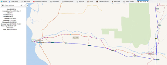
Another example, John said, “We are currently working with our travel team to improve our mapping interface with remote travel. Our operations and project teams work in very remote areas. By integrating our SPOT GPS travel data into our existing spatial data in X-Info Suite, we can quickly overlay our pipelines, facilities, access roads towns and accommodation, and locate where our people are travelling in relation to these. GPS data from vehicles is downloaded into the GIS via the SPOT system every half an hour. Map Activities has enabled us to produce a searchable tool to assist our travel team in managing our people’s remote travel”.
“I’m really looking forward to setting up the new bulk email tool that Mipela recently released in X-Info Connect 6.3. We are increasingly using emails as an efficient form of communication with our landowners and other entities associated with the pipeline. For example, every time we fly for aerial surveillance of our pipelines and facilities, we send an aerial notification email to affected landowners and airports. Recently notifications have extended to CP surveys and dig-ups, ROW slashing and maintenance, and landowner visits. This new function will enable the process to be automated and give the ability to our Lands team to perform themselves”.
In summary John said, “Map Activities have really ramped things up for us. It allows the GIS data to be more and more utilised across the business. We have created Map Activities in X-Info Suite, based on roles and responsibilities, producing tailored maps and reports for those particular people and roles. We are seeing an increasing number of people across the business use GIS, and having quick and simple access to data and maps in the office and in the field is a key to this”.
Popular Posts
A word from the BossTaking mobile data capture to another level
In Focus
Kamapim update
#projectMAD 2024 wrap up – Brissie to Bay ride
Staff update
The importance of Multi-Factor Authentication
Product Update – X-Info Aware
OLDER POSTS:
A word from the Boss
Effective land management across the Gas Pipeline Victoria
It’s the stuff you don’t see that’s keeping you safe
x-infocus tips and tricks
Ampol joins our Client Community!
#projectMAD Special Invitation (14th Year) – RideWithUs!
Staff profile
I’m in a pickle
A Word from The Boss
Mipela are Proud to Protect Qeno’s Botany Assets using the Power of X-Info Assurance suite
Update on our process improvement Kamapim project
x-infocus
Product Update
Mousemats
Staff Updates
Ensuring Smoother User Management: Your Collaboration can Expedite the Process
SA Power Networks – Committed to Ensuring Security
‘Tis the Season
A Word From The Boss
Our cloudy outlook has never looked so rosy
Update on our process improvement Kamapim project
infocus
Product update
Let us in!
Staff update
Providing you that extra level of assurance
Do you have reporting fatigue?
Mipela has invaded New Zealand!
A Word From The Boss
Focus on the complex, the urgent and the sensitive
Update on our process improvement Kamapim project
Making light work of Safety Management Studies
Safeguarding access and data integrity – the significance of using personal credentials to log onto software
A Word from the Boss
Reporting Stakeholder Information to the Regulators
Global Excavation Safety Conference awards Australia’s Glen “Cookie” Cook as the World’s Damage Prevention Hero of the Year 2022
Adding extra assurance to your BYD automated response system
A word from The Boss
APGA POG Incident database
What integration with SPEAR means to Jemena
Sentanil product focus
A word from The Boss
A truly epic project
The true power of data automation for Jemena
Update on our process improvement Kamapim Project
A word from The Boss
Tweed Shire Council using technology to deliver value to ratepayers
Women in Pipelines Forum (APGA)
A word from the Boss
Using software to safely plant trees
How mapping retirement homes helps LendLease manage its 14,000 dwellings
Utilising Map Activities
When it rains it pours
A word from The Boss
Stakeholder management and a global wind energy company
ERA Water automates its asset protection with X-Info DBYD suite
A word from the Boss
ARTC implements X-Info DBYD suite as their automated response system
Beware the Spreadsheet
If you are breaking ground out in the field – we have you covered!
A word from the boss
When community focus is key to the success of your project
How Gladstone Area Water Board saves time processing permits using X-Info DBYD suite
Mipela delivers more efficiencies to APA Group
Helping protect Queensland assets is at the tip of your fingers
Responsive engagement, requires intuitive interactions
Managing Cultural Heritage across Barada Barna land
“The Power of Communication” – see your world from a new perspective
Ever wondered how TransLink manage their Bus Stops?
Managing contaminated land compliance
APGA moves Pipeline Engineers Competency System (PECS) to a a new platform
“Doing the right thing”
Systematising pipeline risk management
The APGA Knowledgebase has moved to a new platform
These are challenging times
Experience really counts when it comes to stakeholder management
City of Greater Dandenong implements DBYD automated response system
Some days are great, some days are good, some days are bad
Stakeholder management – the answer is blowing in the wind
Flavour of the month – renewable energy projects
3 proven ways to empower technology
Automation in Remote Regions Delivers Multiple Benefits to Council
Powering through South Australia
Bringing together data, systems and people
There’s no watering down the importance of DBYD responses at Allwater
Tanami Gas Pipeline data integrity and materials traceability
Incident management and risk analysis of Australasia’s pipelines
Greater Shepparton City Council moves to X-Info DBYD suite
What is X-Info SMS suite?
Putting your pipeline Safety Management Study information in one place
Making Lodging DBYDs Easier
Drawing in the Power of Collaboration
Desktop GIS Analysis for Preliminary Route Selection
X-Info DBYD suite Perfect Fit for ATOM
First Gas Land Management
Managing Your Information
Managing Your Information – from beginning to end
The importance of data across the life of your assets
Mipela assist Luminous Energy in planning solar farms in Queensland
Tasmanian Irrigation
The Value of X-Info Plans Management – Zinfra
Together, we grow
X-Info Plans Management
Real time data capture and reporting in remote field environment made possible with X-Info Aware
X-Info SMS suite – Safety Management Study
Property Information Service made easy
Your competitive advantage in field service management
Remote field task management and data capture providing results for real time consumption for Veolia
TGP optimises their field workforce with mobile data capture app
More than just maps… How do we add value to your GIS?
Working together as a team towards greater success
Automated back end processes provides Gladstone Area Water Board with improved responsiveness for issuing of permits
Four steps for effective business process improvement
Field Data Conversation Efficiency
Treasure your data?
New, bold, brilliant – X-Info Aware
SEA Gas improves efficiency of land management
Reach your business potential with X-Info Aware
Perfect match: X-Info Connect and Maintenance Connection
News Archive
- Summer 2015
- Spring 2015
- Winter 2015
- Autumn 2016
- Winter 2016
- Spring 2016
- Summer 2016
- Autumn 2017
- Winter 2017
- Spring 2017
- Summer 2017
- Autumn 2018
- Winter 2018
- Spring 2018
- Summer 2018
- Autumn 2019
- Winter 2019
- Spring 2019
- Summer 2019
- Autumn 2020
- Winter 2020
- Spring 2020
- Summer 2020
- Autumn 2021
- Winter 2021
- Spring 2021
- Summer 2021
- Autumn 2022
- Winter 2022
- Spring 2022
- Summer2022
- Autumn 2023
- Winter 2023
- Spring 2023
- Summer 2023
- Autumn 2024
- Winter 2024
Tags
- Stories from our clients (50)
- A word from the boss (Hayden McDonald) (23)
- X-Info DBYD suite (12)
- Product news (11)
- X-Info Suite (10)
- X-Info Connect (8)
- X-Info Aware (8)
- GIS (6)
- X-Info Assurance suite (6)
- X-Info SMS suite (5)
- X-Info Plans Management (5)
- X-Info Stakeholder Management (4)
- x-infocus Technical "how to's" (3)
- Works Management module (3)
- X-Info Lands Management (2)
- Stakeholder management (2)
- X-Info WebConnect (2)
- X-Info Service suite (1)